Showing posts with label googlemaps. Show all posts

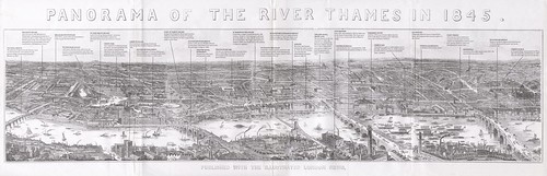
Huge Panorama of London in 1845

In 1845, the Illustrated London News gave away a hand drawn panorama of the Thames running roughly from Vauxhall in the West to just past Greenwich in the East.
Page2

Fortunately, a reprint made for the newspaper’s 150th anniversary, tends to be more affordable, and over at the IanVisits blog they recently acquired a copy – which has been annotated with additional explanatory text. Its really nice that they used our free ImageCutter software to place a high res/zoomable version online - its great.

If you have 5 minutes to spare then we really recommend heading over to IanVisits to take a look and zoom around.

Picked up via spatialanalysis on Twitter (worth following).

Tweetography - New City Landscape Maps

Over the past few months we have been harvesting geospatial data from Twitter with the aim of creating a series of new city maps based on Twitter data. Via a radius of 30km around New York, London, Paris, Munich we have collated the number of Tweets and created our New City Landscape Maps. The maps created by UrbanTick are stunning, detailing the social networking landscaping.


Pictured above is London, below is New York:


UrbanTick has the full run down with New York, London, Paris and Munich, all available in glorious full screen mode via a Google Maps viewer - head over to take a look at the New City Landscapes.

Thanks got to Steven Gray who did the coding and Fabian over at Urban Tick for converting the data into maps, they are a good team.

Making 'Objects' Tweet

You may of noticed that we recently launched our project 'TalesofThings', a site that tags any media to any object using qrcodes or rfid tags:


Once tagged each object basically gets its own webpage allowing comments to be placed, new media added such as YouTube clips, Audioboo, Vimeo etc and new tales tagged to the codes.


An interesting take on this is that once these tags are placed in the wild and scanned with the free iPhone app they become read/writable and therefore location aware. As such any object you tag with the site can 'Tweet' each time it is scanned. If you tag a landmark for example, each time that tag is read you can get a tweet that says 'Hey, I've just been scanned'. Once scanned new tales or comments can be added to that tag, creating a social network of 'things' and 'locations'.

We are working on ways to make the objects more location aware and aware of near by objects, it could be interesting over the next few months to see how this develops. You can see all the things added to far on the 'world of things map':


You can start tagging anything and everything via talesofthings.com