Showing posts with label Virtual Earth. Show all posts

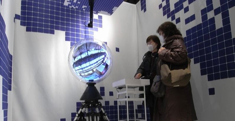
Panorama Ball Vision: Spherical Display


The movie below details a spherical display under the name of Panorama Ball Vision:


The display seems suitable for use with Google Earth or any panoramic based imagery, we don't think the masks in the picture are due to any harmful output from the actual device...

See http://zeroworks.jp/index.html for more images.

Photosynth Now Integrated with Virtual Earth

We have been big fans of the Photosynth technology here at digital urban, it has huge potential for portraying the cityscape from the level of external architecture through to inside buildings and down to individual objects.

Microsoft have just launched Photosynths integration with Virtual Earth along with some tweaks to the interface, the slightly corporate and stumbled through video below provides details:


While it is still early days the example of the House Synth over at http://www.microsoft.com/virtualearth/ details the possibilities, now if they would just let us open the the resultant point cloud in application such as 3D Max....

ESRI and Microsoft Team up for ArcGIS 9.3.1

We knew this was coming and indeed it was possible via other routes but its still quite a notable move with ESRI teaming up with Microsoft to offer Virtual Earth directly within ArcGIS. The full announcement is below:

ESRI Expands Virtual Earth Access in GIS by Teaming with Microsoft

ArcGIS Users to Bring Dynamic Basemaps into Analysis and Service Applications

Redlands, California—March 26, 2009— ESRI announced today a new agreement with Microsoft Corporation that gives ArcGIS users fast access to Microsoft Virtual Earth for their geographic information system (GIS) projects. As part of ArcGIS Online at the ArcGIS 9.3.1 release, ArcGIS Desktop and ArcGIS Server users will be able to connect directly to Virtual Earth and quickly start their GIS projects with ready-to-use content.

"Our agreement with Microsoft defines a pattern of sharing geospatial data on the Web that promises to grow the GIS community," says ESRI President Jack Dangermond. "By bringing Virtual Earth into their GIS projects, people will have a greater opportunity to perform spatial analysis based on dynamic data."

image

ArcGIS users who are current on maintenance and have an Internet connection will have access to Virtual Earth for a variety of up-to-date mapping content.including aerial imagery, roads, and hybrid (aerial with labels) imagery. With a familiar look, imagery access will appear as another data layer in GIS. The imagery will provide excellent background maps on which users can overlay their operational data. This means users will be able to focus more on their business data than on its context.

For example, an electric utility can layer its distribution line data over a Virtual Earth aerial view of a neighborhood to create a map of its lines and customer connections. This Virtual Earth background layer is useful for editing the company's data and can be easily shared online with other company users.

ArcGIS users can build Web applications that support geospatial services through ArcGIS Server and ArcGIS Web Software Developer Kits (SDKs) , including APIs for JavaScript, Flex, and Microsoft Silverlight. This enables them to provide their clients with access to Virtual Earth content from their applications.

“ESRI and Microsoft share a long history of building geographic information systems solutions that combine both of our companies’ strengths,” said Chris Sampson, director of Virtual Earth at Microsoft. “By integrating Microsoft Virtual Earth across all ESRI ArcGIS products, we can provide our mutual customers with spatial analysis software that has instant access to comprehensive geographic data that can only be found in a software plus services solution.”

ArcGIS Desktop 9.3.1 users who are current on maintenance will be offered access to Virtual Earth at no cost. ArcGIS Server 9.3.1 users will have instant access to a built-in 90-day evaluation of Virtual Earth. After the evaluation ends, ArcGIS Server users will be able to purchase an annual subscription that will be based on transactions.

For more information, visit www.esri.com/agolwhatsnew.
Tilt Shift Maker: Free Tilt Shift Image Editing for Mini Cities

Tilt Shift photography is perfect for creating pictures of real-life scenes that are manipulated to look like model photographs. Thankfully you no longer need an expensive lens or a moderate level of expertise with Photoshop to make them thanks to Tilt Shift Maker.

Tilt Shift Maker is a free service that allows you to upload photographs up to 4Mb in size or 4096 x 4096 resolution and set the size/area of blur to create the tilt shift effect. Once your happy with your creation simply click 'download' to get a full size tilt shift image back.

Its a really neat service and completely free, you can use any photograph but oblique angles work well for tilt shift, as such Google Earth or Virtual Earth are perfect for trying out the effect.

See http://tiltshiftmaker.com/

For more examples see our post on Tilt Shift Mini City Videos

Embed Virtual Earth into ESRI's ArcGIS

The excellent Arc2Earth from Brian Flood has always had the ability to display map tiles from Microsoft, Yahoo and Ask.com as a custom layer in your map.

What is new in the current beta release is the ability to directly embed the API from Microsoft and Google into ArcMap - the movie below explains all:

<a href="http://video.msn.com/video.aspx?vid=e9a8d421-7e9c-4544-848f-568a948e4410" target="_new" title="Arc2Earth - Virtual Earth">Video: Arc2Earth - Virtual Earth</a>


As brian states on the Spatial Data Logic Blog, you can drape your own data over the existing globes and then use this as an element on your Page Layout for exporting to either paper or digital copies. The process of draping your current map over the globes happens automatically and on a background thread, so its really intuitive to work with and doesn’t stall the main thread ArcMap uses for most of its own work . As you change your Map contents in the TOC, the changes are reflected on the globes as well.

Find out more via http://www.arc2earth.com/

Microsofts Sphere: The Ultimate Virtual Earth Viewer?

Touch tables, touch tablets and touch phones are all well and good to explore the emerging interfaces and applications of computing but if you spend most of your day immersed in digital geography you really need something more 'earth' shaped.

Step forward Microsoft with the first demonstration of the 'Touch Sphere', the movie below shows it in action.


Of note is the short demo of the system with a image of the earth. We have already cleared space in the lab ready to house it...

Thanks to Kirk for sending us the heads up, take a look at Todd Bishop's Microsoft Blog for more details.

Microsoft Makes trueSpace Free: Head to Head with Google SketchUp (?)

We have always had a soft spot for trueSpace, the 3D software package from Caligari. It was one of the first modellers we used back 10 years ago for ActiveWorlds.

Google SketchUp has been without question the tool of choice in recent times with its direct link to the 3D warehouse and Google Earth. Its one of the best examples of Web 2.0 in action and a almost genius way of getting users to populate 'Google Earth' for free.

Microsoft has been lagging behind in terms of free tools and with it users, community and content so its interesting that today Microsoft announced via Chris Pendleton's blog that trueSpace the previously $595 3d authoring package is now free with the explicit aim of adding content into Virtual Earth.

The language in Chris's post is interesting (note the SketchUp dig):
"As you'll recall, several months ago we acquired Caligari because of their advanced 3D toolset - trueSpace (among other assets). I've always felt sketchy about other 3D freeware, so starting today trueSpace 7.6 is now available for download.....FOR FREE! And, there is a direct connection into Live Search Maps so you can create SUPER high resolution 3D models using trueSpace, then right from the environment upload the model into Live Search Maps as a collection item. Once you've created your collection, you can import your collection into your Virtual Earth application and BAM you have your own custom 3D models in your Virtual Earth application. We'll host the models right in our 3D collections cloud..."
The learning curve maybe slightly higher than SketchUp and its not quite aimed at the same community, but it imports all of the major file formats and puts them direct into Virtual Earth.

Interesting times ahead for sure, see Announcing trueSpace for Virtual Earth 3D Development for full details and a download link. There is no announcement on the main Caligari site yet.


Thanks to Ogle Earth for the heads up.

CamSpace: Gesture Control for Google Earth/Maps/Virtual Earth?

The video below details CamSpace a program that quickly and easily allows the user to set up object tracking to emulate mouse or joystick movement/clicks. This means that any PC (Mac and Linux coming soon) application or game could be controlled simply by using gestures.


It has a lot of potential for geographical applications, especially in exhibition/demo spaces. In some ways its similar to our previous work with Atlas Gloves and Google Earth using two ping pong balls and a LED light - movie below:


All you need is a webcam, see CamSpace for full details.

Buy the Booklet: Digital Geography - Geographic Visualisation for Urban Environments


*UPDATE*

The Booklet is now Sold Out

****

We are pleased to announce the availability of our booklet: Digital Geography - Geographic Visualisation for Urban Environments. Printed in full colour the 10 x 8 inch booklet runs to 64 pages of insights and tutorials on Virtual Earth, Google Earth, Google Maps, Panoramas and Second Life.

With a focus on Neogeography, Web 2.0 and the various emerging techniques for urban visualisation the booklet has been written as a preview to the forthcoming Digital Urban 'recipe book' to be published fourth quarter of 2008.

The booklet is being sold at below cost price and is available now. For all those that have emailed to reserve copies, thank you, these are set aside and guaranteed for shipping soon as payment is received.


Priced at £9.99 (worldwide postage and packaging is free) it can be purchased direct via the Buy Now link using PayPal or any standard Credit/Debit card:


If you have any questions drop us a email or use the usual comment link.

We hope you enjoy the booklet.....

Digital Geography: Geographic Visualisation for Urban Environments - The Booklet


Our booklet: Digital Geography - Geographic Visualisation for Urban Environments has just come back from the printers and its looking good (even if we do say so ourselves). Printed in full colour the 10 x 8 inch booklets runs to 64 pages of insights and tutorials on Virtual Earth, Google Earth, Google Maps, Panoramas and Second Life.

With a focus on Neogeography, Web 2.0 and the emerging techniques for urban visualisation it has been written as a taster of the forthcoming Digital Urban book to be published fourth quarter of 2008.

The booklet should be available to purchase at the below cost price of £9.99 from this blog next Wednesday 26th March (ie after the Easter Closure). Supply is limited so feel free to drop us a email in advance if you would like a copy reserved, world wide postage will be free.