Data Mash-Ups and the Future of Mapping: JISC Report
MILF Mapping Service: Not What You May Think

Gowalla MILF to find spots around you which contain any of these items. Just connect with your Gowalla username, and you’re good to go.
I guess their hits will be quite high, but not sure how long the visitors will stay around for....
Spark of Genius Series: TalesofThings QR Codes and Life Logging
Quick Pitch: Adding memories and stories to objects and places via the Internet of Things and read/write QR codes.
Genius Idea: The Internet of Things is a growing trend; the term defines the idea of objects that are tagged, web-connected and endowed with the ability to relay data. This startup is all about the Internet of Things; in fact, it helps ordinary people add objects to the Internet of Things with just a few simple tools, such as a smartphone and a printer.
Tales of Things has developed read/write QR codes that helps preserve memories that people have attached to objects or places. Once an object is labeled with a scannable QR code, its movements can be tracked, as well as any subsequent stories. Each object has the ability to tweet when its memories are scanned, as well.
All the user has to do is photograph the object or place to be tagged, write a few words or upload a video about it, print out a site-generated QR code and affix the code to the item or at the place. From that point forward, the place or thing can be tracked through TalesofThings.com.Think of the site as an “antique roadshow of the future.”
Every object in existence can be tagged with any media, linked to tell a story, to recount its memories in a read/write environment and tweet when its interacted with.
Its a concept that takes a bit of time to take in, for example a wall in Camden Town, London, tweeted me last week when someone replayed its memories of having a Banksy painted on it. That wall is part of the Internet of Things via our free printed qrcodes.
The best part is, its incredibly easy to add objects. You simply sign up at talesofthings.com and then take click on 'add a thing'. This takes you to a form where you give your object a name, for a example 'Andy's Mug' or 'BBC Broadcasting House' are some of things we have added so far. You then type in a short story, or tale, linked to that object and upload a photograph to the site.
Everything has a location so we are creating a 'Geography of Everything', a brave claim perhaps but one that develops a new a new kind of geography, the geography of things. Simply click on the map to set a location, your object will now become part of the 'World of Things' map.
Thats it, your object will now become part of the Internet of Things and will be able to tweet, have new stories/tales added as its passed on, sold or interacted with. It is all part of a Social Web of Things or SWOT as its known.
Each thing created gets assigned a unique 'qrcode' which can be attached to your object. For example, we have attached a qrcode to our office here in CASA which visitors scan using our free iPhone app. This 'virtual guest book' allows our office to recall the story of CASA and the people that pass through our doors. You can print out your codes via the site and attach them to anything.
Any media can be added to you object, the clip below provides a glimpse of the system running via our recent link up with Oxfam via Future Everything, complete with the iPhone RFID reader:
We have recently pushed an update that introduces 'groups' so all objects of interest can be viewed in one place. As all things urban are close to our heart, one of the first groups is 'Architecture' and we would like you to add your own building with a story.
Its simple to do, just sign up, upload a image of your building of choice (under 2mb) and add a story. Your building will then go live and your be able to add it to the architecture group. If you want you can also print out a QRCode that you can stick to the building allowing anyone to scan the code and add to the story/history of the building via the free iPhone/Android apps.
Your building will also be able to 'Tweet' everytime it is scanned or a new comment/story added, it will also become part of the 'World of Things' map - a place to view all the objects added so far to the site.
We are working on ways to make the objects more location aware and aware of near by objects, it could be interesting over the next few months to see how this develops. We look forward to seeing some of your buildings on the site and will sort out some sort of prize for the best stories...
Finally TalesofThings.com allows any object to be given its own webpage and ability to tweet, i.e. it allows any 'thing' to become connected. As such we have built an 'Arduino Thing' that welcomes all new objects joining the Internet of Things with a 'Hi' in Morse Code - the movie below reveals all:
iPhone App: Walking Through Time - Edinburgh Edition
Its a great concept, the movie below provides more details:
We hope to see more cities become available over the coming months, get in touch with Chris Speed from the Edinburgh College of Art for more details.
You can download the free app from iTunes.
SurveyMapper Trailer: Survey the World a Nation, City or Town
If you have used other ‘polling sites’ then you will be up to speed, except we have taken away the restrictions and added real-time mapping into the mix. Simply sign up (its free) and then your be able to create your own survey. Currently we have four levels of survey available - Worldwide, based on countries, European Countries and UK Counties/Authorities and Postcode.
Head over to SurveyMapper.com to create your own survey or answer the surveys already running.
SurveyMapper: The First Surveys
Now we have the first surveys set up by the early adopters, including:
Is Britain becoming a Police State? (its a controversial start...) (take part)
How Many Hours a Week do you Work? (take part)
The Future of Twickenham (take part)
The Beasts of Scotland (take part)
To take part or create your own survey head over to SurveyMapper.com
Keep up with the SurveyMapper twitter feed for news on the beta release, new features such as blog embedding and integration with our now infamous Tweet-o-Meter and New Cityscapes via Twitter Maps.
You can of course also follow us direct on Twitter @digitalurban.
Introducing SurveyMapper: Beta is Now Live
Do you want to know what peoples views are on the issue of the day, do you want to ask peoples views on a new product, perhaps you are carrying out a straw poll or do you want to collect data to input into a scientific model? All you need is SurveyMapper.com.
You can ask anything, survey the nation, the world or just your street with real-time mapping and statistics.
To take part or create your own survey head over to SurveyMapper.com
Keep up with the SurveyMapper twitter feed for news on the beta release, new features such as blog embedding and integration with our now infamous Tweet-o-Meter and New Cityscapes via Twitter Maps.
You can of course also follow us direct on Twitter @digitalurban.
Satellite Car Chase: Google Maps Animation
The movie was made and directed by http://stayhonest.com/
Google Buzz Layer on Google Maps: The InfoCrowd
Interesting and big enough to cause an upset in the current social networking scene, also powerful enough to change the way we view information about the city.
Visit buzz.google.com from your phone's mobile browser to start using buzz.
Adverts in Street View - Could be Video?

Its interesting how the mouse in Street View follows the 3D space, we assume to allow any data to be tagged to buildings etc. With data of course comes the ability to provide click throughs and advertising. We dont think it will limited to simple images however as video can also be embedded into panoramas as one of our previous examples shows:
San Francisco Panorama with Embedded Video from digitalurban on Vimeo.
The example was quite easy to produce, we used the real estate of Twin Peaks in San Francisco, but this could of easily been an advert above Buckingham Palace and then that's when things get interesting...
View the live version of the San Francisco video embedded in panoramic space.
Historic Mapping on iPhone/Android - Walk Through Time
The movie clip below provides a neat guide to the concept:
In short, we really like this, the ability to load up a historical map based on your current location opens up all sort of possibilities from historical tours through to viewing the changing layout of the city over time.
The project is funded through a JISC grant and is collaboration between Edinburgh College of Art (ECA) and Edinburgh University (UoE) with development led by Chris Speed and Ian Campbell of ECA with Tim Urwin, EDINA / UoE, Petra Leimlehner, UoE,Peter Pratt, UoE, Karlyn Sutherland, UoE.
The app is currently in prototype form - keep an eye on http://walkingthroughtime.eca.ac.uk/ for more news on a release.
Monopoly City Streets: Google Maps/Earth and SketchUp?

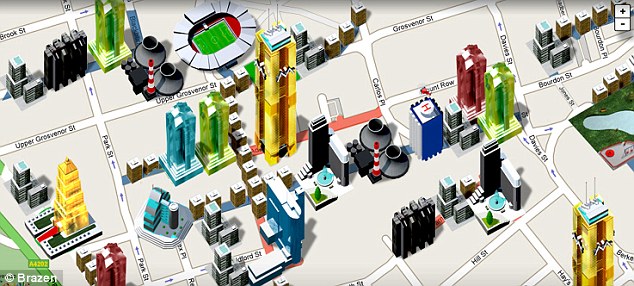
Google has teamed up with the people behind Monopoly to launch a global online version running on top of Google Maps and perhaps Google Earth (?). Details are scarce at the moment but an announcement is imminent via both the game's official site and the blog.
Of note is the mention for SketchUp users to check back September 7th (today)....
Population Density: Google Maps Census System Preview
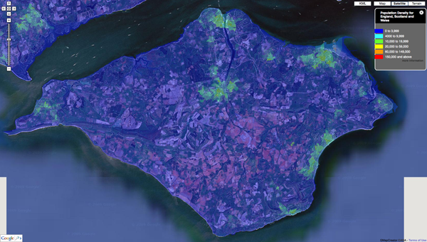
Our first of many outputs is to visualize the UK Census data via MapTube and we thought we would share some of our first results as they make for quite intriguing images - such as the screen grab below detailing Population Density of the Isle of Wight:

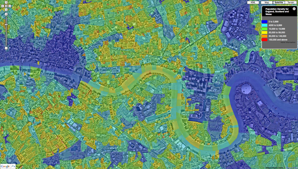
The work is ongoing with the ability to 'click' on areas and view the underlying data as well as data streaming and varying levels of detail all forthcoming. Countywide, zoomable down to local level Cenus data is hard to come across, for a quick view is provides quite a good way to identify pattens in the urban landscape. Below is Central London:

Our back end system under development means that the output is not limited to the UK Census, it would be interesting to make this a global tool, more on this in future posts...
You can see our sample map of Population Density direct via MapTube.
GMapCreator: Clickable Thematic Maps Preview

Over at the GENeSIS blog Richard Milton of CASA has put up a sneak preview detailing some of the functionality of the latest GMapCreator. Traditionally clickable maps have been built using a server and database to translate the click on the client into a geographic area using point in polygon and then sending the query data back to the client. This method doesn’t scale when you have limited server resources and are looking to handle high numbers of hits, for example with the Mood Maps that we’ve been doing recently. An alternative solution is to build feature coded tiles and let the client handle most of the work displaying the data.
In short, its clickable Google Maps at a large scale without any slow down compared to other solutions, take a look at the GENeSIS blog for more info...
This build will be integrated into our MapTube site as soon as ready for wider use. As a side note MapTube is now includes the option to view your data on top of OpenStreet Map layers.
Urban Spaces: Search Google Maps by Shape and Size
Urban Spaces is a beta service from Holistic City Software that allows urban designers, architects, developers and planners to search for examples of public spaces of a specific size or shape.Our movie below provides a quick insight:
Searching by size and shape is actually quite addictive and it is certainly an innovative way to use Google Maps.
To try it for yourself go to http://www.holisticcity.co.uk/urbanspaces/
MPs' Expenses Map on MapTube
In recent weeks the level of expenses claimed by Member of Parliament in the United Kingdom has been hitting the headlines. Thanks to MapTube here at CASA it is now possible to view a map of the UK detailing MPs' expenditure from 1 April 2007 to 31 March 2008, the map is coloured to show the total amounts being claimed by MPs in each constituency.A new feature to MapTube is the ability to include clickable data ontop of the map, each 'i' link contains more detailed information about the rules governing MPs' allowances and how much can be claimed for in each of the 8 categories.
The total expenditure for all 646 MPs is £86,781,20;
The mean is £134,544.5;
The maximum claim was for £167,306 by Ann Keen of Brentford and Islewort;
The minimum claim was for £40,433 by Philip Hollobone of Ketterin;
The data for the Crewe and Nantwich constituency (Edward Timpson) and the Glenrothes constituency (Lindsay Roy) are missing from the original dataset.
Note the information does not show members' travel expenses, which are in a separate table to the allowance expenditure.
You can view the map direct via MapTube.
Google Map Maker Timelapse
Google Map Maker is a Google Maps service that allows users to add or edit features, such as roads, businesses, parks, schools and more. It is a classic Web 2.0 methodology to map the regions of the world that are not already covered by the Google Maps and we kind of like it.The timelapse video below illustrates Madurai, India being mapped:
Only certain regions of the world are available to edit/map, for obvious reaons, a complete list of areas can be found on the Map Maker site.
The next video details Nicosia, Cyprus:
Google explains the concept of Map Maker below:
Its quick, easy, moderated and provides a publicly viewable basemap in areas where mapping maybe limited. If you are logging in from a part of the world not covered by Google Maps then Google Map Maker is well worth a look...
Google Maps for Fine Art: The Kremer Collection and Image Cutter
As such we assumed it would be used by panoramic photographers, architects and perhaps a few geographers. It turns out it has also been used by medical imaging experts and more recently to share and display fine art courtesy of the Kremer Collection.
The movie below provides a quick insight into how the site works:
Image Cutter: Displaying High Resolution Images on top of Google Maps from digitalurban on Vimeo.
The Kremer Collection is owned and managed by the Fondation Aetas Aurea (FAA). The collection comprises 17th century Dutch and Flemish Old Masters. The collection contains 48 paintings and copperplates by Dutch and Flemish masters. Many great figures are represented, including Hendrick ter Brugghen, Gerrit Dou, Frans Hals and Rembrand.
It is really nice to see the software used in ways we had not previously envisaged. You can find out more about Image Cutter and downloaded a copy (its free) from here.
Thanks as ever go to the National Centre for e-Social Science who funded our project.
MapTube: Geographic Surveys - BBC Manchester and Radio 4
Thanks go to our funders on the project - the National Centre for e-Social Science at Manchester University for setting this one up. Its nice to see maps used as part of a news item, MapTube was developed as part of our GeoVue grant at CASA (home of digital urban) to develop a free and easy way to share, mix and match professional maps online via the Google Maps interface.
Secondly Radio 4's PM show is running an update to their Credit Crunch Survey - see the iPM post Credit Crunch: The return of the map.
Finally, although not a survey, MapTube also has a new map online detailing the money invested by UK councils following the collapse of the Icelandic banks.

View the Iceland Banks Money Invested Map.
Take part in the BBC Radio 4 Credit Crunch Survey.
Have your say on the Manchester Congestion Charge via BBC North West.
London Gets Non-Google Street View: Seety and Earthware

Seety have beat Google somewhat to the table with a pretty comprehensive coverage of central London using street based panoramic imagery.
Navigation is nice, although not quite as smooth as Googles own street view product, the main question we have to ask is why? Its well known that Google is currently driving the streets of Europe capturing imagery and with it bound to be a default layer in a few months you have to ask why anyone else would do it?
London UK street level views, but not from Google from Brian Norman on Vimeo.
Licencing and use of imagery maybe a factor - Seety is being used by Earthware (a company worth watching) in the the latest version of our Earthware Property real estate mapping solution. The movie above demonstrates Seety imagery within the Earthware interface.
However with open use of the Google API we assume that property searches will make copious use of street view as soon as its available and where does that leave Seety (?)
Lots of questions we know...
See http://www.earthware.co.uk/ and http://www.seety.co.uk/ for more info and demos.