Showing posts with label Google Earth. Show all posts

3D London: Google Earth

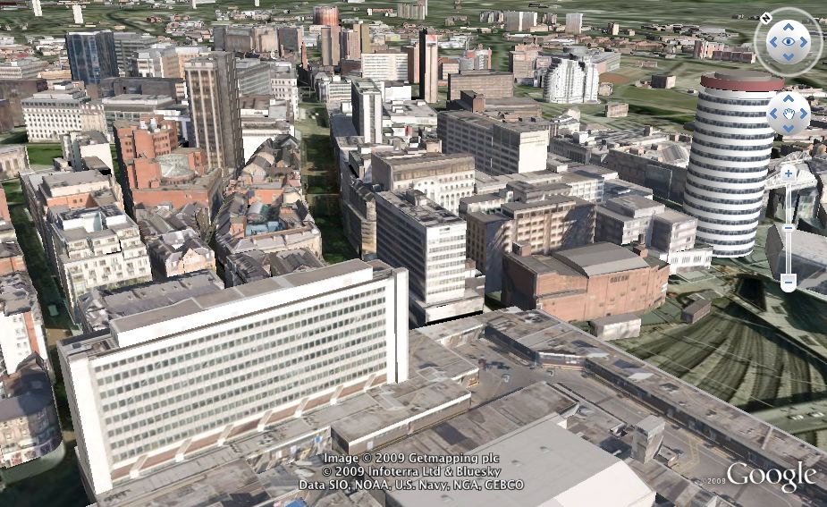
With recent developments here in CASA we somehow managed to miss the addition of automated 3D models into Google Earth for London. The mix of hand made and we presume LiDAR derived models is stunning with resolution down to modelling the chimneys on many buildings:


The quad at University College London is notably impressive, as is Trafalgar Square. The model is far from complete but we assume other areas are on their way.

Music: London Town by Rod Kinny on unsigned.

SketchUp 8: Google Building Maker Direct in SketchUp

Google has announced the new features available in SketchUp 8. The highlight in our eyes is the integration of Google Building Maker direct into SketchUp.


Any building maker building in Google Earth can be imported, combine this with exports to Unity/Crysis etc and just think about the possibilities...

Download for free at http://sketchup.google.com

London Cycle Hire in Google Earth

Adrian Short, the person behind the fantastic Boris Bikes API which serves live data about bike and docking station availability has created a visualization in Google Earth detailing current bike availability across London:


To view the live version and see full details on how it was done - head over to Adrian's blog post. For more about design, citizenship and city keep an eye on http://adrianshort.co.uk/

Navigate Google Earth with Two Ping Pong Balls and Some LEDs

While thinking about new ways to control and navigate geographical visualisations we came back to some previous work using two ping pong balls and two LEDs to fly through Google Earth.

Based on the Atlas Gloves system we utilized a projector displaying Google Earth and the control software in a blacked out lecture theatre. This allowed a clear view of the lights which are turned on and off in combination with various hand gestures to remotely control Google Earth.

The movie below demonstrates the trial, we were going to leave the movie audio free but couldn't resist dubbing in the The Sorcerer's Apprentice by Stokowski.

Linking Google Earth to a remote vision based control interface is quick and easy and the fact it worked first time is testament to the teams clear instructions and software.


Take a look at Atlas Gloves to try it out yourself.

A-Team: Drive the Van in Google Earth

Google Earth still amazes in terms of visualisation and in the latest development, planetinaction has created a 'game' linked to the up and coming A Team movie:


YouTube can be a harsh place to be sometimes and the comments on the various clips have been cutting. What needs to be remembered is that this is running in Google Earth and for us that stands as some achievement.

Click here and play the game.

Picked up via the ever excellent Google Earth Blog

Skape - 3D City Viewer and Download Tool: New Movie and Demo Online

Earlier this week we had the pleasure of meeting the people from Infoterra for a demo of their recently released 3D city viewer. Known as 'Skape' it enables you to view and perhaps more importantly upload and download highly realistic 3D environments, for visual concepts and interaction with building information. With 12 cities in the UK now available the level of detail and fidelity in the textures is notable. We tend to get quite a few companies through the doors of CASA with 3D models and we can honestly say Skape is the best we have seen so far. The movie below provides an overview, its interesting to see how far the industry has come in just a few short years:


Skape is designed as a professional tool, moving it away from the current models and level of functionality found in Google Earth or Bing. It is aimed at a range of industries, including architecture, planning, building development and environmental consultation. However, it is free to view the cities and at the moment free to create movies as well, as such it makes for an interesting spatial analysis and visualization tool.

Take a look at http://www.skapeworld.com/index.htm for more info and to try it out.

London Twitter Cloud

Regular readers will know we have been logging data in 12 cities via our Tweet-o-Meter, its still early days but the results for a weekend in London are intriguing.


The data covers a weekend period from Friday evening to Monday morning containing 380,000 individual tweets. Within these 60,000 were geo-referenced, tweeted by 5,500 individual users.

In terms of density the focus is on central London with local hotspots as the weekend progresses, around Kings Cross and Old Street. There is also a noticable trace along the main transport routes into and out of town, noting that we seem to be tweeting while on the move. The clip below details the visualisation in Google Earth:


Music - 'Social Awkwardness' by Xanthe  over on unsigned bands.

The clip reveals a message cloud rising and hovering above London as a time-space aquarium where the time is plotted as the height information. Interestingly Google Earth is becoming the visualiser of choice for such data sets, the combination of location, imagery with the ability to view by time makes it a formidable engine for data visualisation.

Thanks go to urbantick who converted the data via a custom VB script.

Google Earth - Creating a Zoom Movie

A quick post as few years ago we wrote a tutorial on creating a 'zoom' movie from Google Earth, it involved all sort of issues with paths and local caches and reversing frames. Nowadays its simply a case of 'right clicking' in Google Earth and dragging the mouse:

Google Earth Zoom from digitalurban on Vimeo.


Google Earth fixes on the location (in our case the CASA offices) so you can drag back and forwards for a smooth zoom in/out. The movie was recorded using Snapz Pro on a Mac but any screen recording tool would do. Its nice to know that this is so much simpler now, although slightly worrying that i almost take a digital earth zooming out and back in at high resolution within 15 seconds for granted...

Google Earth - Live Building/Billboard Texturing from Webcams: Live3D

We have just spent the last 30 minutes wowed by 'Live 3D' sent to us by Austin Abrams, a graduate student at Washington University in St. Louis. In short Live 3D is a Google Earth-powered web application that allows users to transform photos into 3D geometry in Google Earth - ie you can drap webcams onto the buildings for a 'live view' of a city and it has notable potential for a live Google Earth.


The camera is automatically calibrated, revealing its location and orientation (take a look at, this scene, the position and orientation of the camera is automatically generated, which closely matches the real webcam image).

The group has been archiving 1000 webcams for the past four years, as the Archive of Many Outdoor Scenes. If the user gives Live3D an AMOS camera, the application can re-texture the scene based on time-lapse imagery. So, you can see what the scene looked like a week, a month, or a year ago.

Urban scenes seem to work particularly well, because billboards and other advertisements aren't as static as the Sketchup models suggest. For example, the model for Times Square still advertises Spiderman 3.

To see if live goto: http://amos.cse.wustl.edu/live3d/

3D Mash-Up Maps let you 'Edit' the World

This weeks NewScientist has a good article entilted '3D mash-up maps let you 'edit' the world. Written by Colin Barras it notes that armchair explorers who soar over 3D cityscapes on their computer may be used to the idea of maps with an extra dimension. But they are now getting accurate enough to offer much more than a preview of your next holiday destination. Accurate, large-scale 3D maps could soon change the way we design, manage and relate to our urban environments.'

Colin dropped us a email here at digital urban, our thoughts are included in the article - you can read the online version via the NewScientist website.

Valencia, Spain 3D City

The 3D cities roll out continues at increasing pace - the movie below captured by YourWorldIn3D details Valencia, Spain:


Its certainly impressive, Google's increasingly strong focus on geographic information is of note...

3D Birmingham now in Google Earth


Google Earth has taken some notable strides forward recently with the inclusion of auto generated 3D cities. To such a level that the output rivals Microsoft's Earth which for a while did have the lead in terms of visual quality. The Google Earth blog reported last week that Cardiff and Dublin had been added and now Birmingham joins the throng - see the movie below:


We are really impressed, the city actually looks like the city should, the auto generation system holds up well with the facades of the buildings not suffering from the traditional 'stripes' as seen in other models. It would be nice to see each building 'click-able' allowing for the integration of data within the built environment but we are sure this is coming. These are exciting terms in terms of 3D cities.


Thanks go to Phil for his comment in our Google Earth in Second Life post regards the model...

Monopoly City Streets: Google Maps/Earth and SketchUp?


monopoly city streets
Google has teamed up with the people behind Monopoly to launch a global online version running on top of Google Maps and perhaps Google Earth (?). Details are scarce at the moment but an announcement is imminent via both the game's official site and the blog.

Of note is the mention for SketchUp users to check back September 7th (today)....

SketchUp to Google Earth Timelapse

Reader will know that a couple of main themes here on digital urban are timelapse imagery and 3d modelling, as such the movie below appeals as it features both:


Created by db3d2 the movie is actually an interesting insight into the photograph to SketchUp to Google Earth modelling process.

See http://www.db-3d.com/blog.html for more info.

Google Earth API Premiere: New Classroom Geography

Roundarch has developed new geography software for NYSTROM Herff Jones Education Division, the makers of maps, atlas and globes for schools. Called StrataLogica, the web-based software utilizes the Google Earth API Premier platform from the cloud to create an interactive 3-D experience for classrooms.

The movie below provides an intriguing demo:


In our day we had to do with 'books' and the odd 'atlas' shared between groups of four, how times have changed in the teaching of geography...

Find out about more about the system via http://www.nystromnet.com

Panorama Ball Vision: Spherical Display


The movie below details a spherical display under the name of Panorama Ball Vision:


The display seems suitable for use with Google Earth or any panoramic based imagery, we don't think the masks in the picture are due to any harmful output from the actual device...

See http://zeroworks.jp/index.html for more images.

Google Street View Timelapse: The Raw Data

Google's Street View is without question the most ambitious panorama projects to date and the movie below provides a glimpse of the raw data captured. As the poster vipersniper32 states - four days, 3,642 GPS data points and one blatant violation of Google's Terms of Service:


So above is the raw data, if you have time and the patience you can create a timelapse from the actual final product:


The timelapse drives up Hennepin Avenue in Minneapolis - its almost tempting to make one ourselves...

Google 2009 - Advanced 3D Geo Apps for Web: Earth API

In 2008 Google announced the Earth API and Google Earth Plugin tandem as a pioneering new avenue for 3D content delivery on the web. The API made it possible for developers to create high performance, rich, geospatial web applications purely in JavaScript and HTML. In the movie below Roman discuss advanced Earth API topics such as programmatic regionation for visualizing large datasets, user interaction techniques, and 3D animation. Its a 55 minute runtime but well worth grabbing a coffee and sitting back to watch:


For presentation slides and all I/O sessions, go to: code.google.com/events/io/sessions.html

Google Tours - 3D Buildings and World Skyscrapers

Google has added 3D Tours to its Google Earth Gallery, of particular note is the 3D Buildings category. The category provides a number of self-running tours on various themes. The tours showcase 3D buildings (along with bridges and statues and other structures) around the world, most of which were built by Google SketchUp users.

We recommend the world skyscrapers tour, take a look at the full list of tours available via the gallery.

Urban Tick: Google Earth as a Visualisation Engine and the Trails of Ants

Urban Tick over at urbantick.blogspot.com is becoming a 'must read' we know we are slightly biased as it comes out of the same lab as us here at digital urban, but the work is really starting to look interesting. Two posts grab our attention, firstly the Urban Diary Week 3 with two movies recorded in Google Earth with the satelitte view turned off - this is interesting as its using Google Earth purely as a visualisation engine. Secondly, a post on Ant Trails and couple of great movies on visualising their paths.

We would normally embed the movies in a post here but for this one we suggest heading over to Urban Tick and taking a look.