Showing posts with label iphone. Show all posts

Introducing QRator - iPad and Web Based Living Labels for Museums

QRator is a collaborative project between the UCL Centre for Digital Humanities (UCLDH), UCL Centre for Advanced Spatial Analysis (CASA), and UCL Museums and Collections, to develop new kinds of content, co-curated by the public, museum curators, and academic researchers, to enhance museum interpretation, community engagement and establish new connections to museum exhibit content.
The interactive system is designed to be non intrusive while enabling members of the pubic to simply type in their thoughts and interpretation of museum objects and click ‘send’. Their interpretation become part of the objects history and ultimately the display itself via the interactive label system to allow the display of comments and information directly next to the artefacts.
The project is powered by Tales of Things technology which has developed a method for cataloguing physical objects online and capture memories and stories via the Internet of Things. QRator takes the technology a step further bringing the opportunity to move the discussion of objects direct to the museum label and onto a digital collaborative interpretation label, users’ mobile phones, and online allowing the creation of a sustainable, world-leading model for two-way public interaction in museum spaces.


At its heart QRator is an iPad/iPhone and web based system that allows everyone to be a curator and share their views on an exhibition. Visitors can examine an object before leaving their thoughts via an iPad to create a digital, ‘living’ label that subsequent visitors can read and respond to.


By downloading a free application to an iPhone or android phone, visitors are able to see rolling updates to the digital label after they leave the museum, or via twitter. Participants are also able to take part in the conversation online via the QRator site with comments appearing live within the museum.


Content currently covers two museums at UCL; The Grant Museum of Zoology and The Petrie Museum of Egyptology. he Grant Museum of Zoology is one of the oldest natural history collections in England, dating back to 1827. The collection comprises over 68,000 skeletal, taxidermy and wet specimens, covering the whole of the animal kingdom. Many of the species are now endangered or extinct including the Tasmanian tiger or thylacine, the quagga and the dodo. The Grant Museum is the only remaining university zoology museum in London.
The Museum will offer a continual programme of ‘Current Questions’ for visitors to engage in. UCL is taking the opportunity to rethink what a university museum can be; a place not simply for a passive experience but for conversation – a cultural laboratory for the meeting of minds. Positioning the Museum as a place of experimentation, dialogue and debate.

You can join the conversation by visiting either the Petrie or Grant Museum or by simply heading over to http://www.qrator.org all comments appear live on the iPad screens in the Museum and on Tales of Things.

3D City on the iPad (Movie)

Mobile 3D City, the people behind the excellent Paris 3D application on the iPhone have released a movie detailing a 3D City dataset from Blom running on an Ipad:


In many ways the iPad is the perfect device for exploring 3D cities, we spent the weekend playing about with Google Earth on the device and its impressive. Of course the introduction of 3D buildings takes it to a new level...

iPhone Timelapse - A Gorillacam Quick Post

A quick follow up post on our previous first look at the free Gorillacam app for the iPhone. Despite the iPhone known camera limitations it still does a good job at timelapses with enough resolution to add in various panning movements as per our latest clip below:


Music is courtesy again of unsigned band - Lemonade Joe.

Get Gorillacam Free through iTunes

Timelapse on the iPhone: A look at the free Gorillacam App

Joby, the people behind the Gorillapods, have released a free camera app for the
iPhone entitled 'Gorillacam'. Of note the application features a timelapse mode allowing multiple photos spaced at various intervals, ranging from 1 second apart, up to 2 minutes. We have run a few tests and with a first generation iPhone 10 seconds is the most reliable time frame to chose due to the time taken to save an image, second and third generation seem to cope with faster times. That said, 10 seconds is nigh-on-perfect for timelapses and the application does a sterling job.

We set the application running on an overcast winters day and the output of 1600x1200 jpgs is more than enough to output a 720p (HD) movie to YouTube with room for some post processing pan movement:


Music is courtesy of the rather good unsigned band - Lemonade Joe.
The movie was made simply by opening QuickTime Pro 7 and selecting 'image sequence' with the pan added via After Effects. The iPhone camera is never going to win awards but for a quick timelapse then Gorillacam is a must have for any iphone user, especially at the price, ie free.

Get Gorillacam Free through iTunes

Historic Mapping on iPhone/Android - Walk Through Time

Walking Through Time is a research project developing iPhone and Android apps that architectural historians, conservationists and tourists to swap the Google base map for a historical map - i.e., allowing a user to 'Walk Through Time'.

The movie clip below provides a neat guide to the concept:


In short, we really like this, the ability to load up a historical map based on your current location opens up all sort of possibilities from historical tours through to viewing the changing layout of the city over time.

The project is funded through a JISC grant and is collaboration between Edinburgh College of Art (ECA) and Edinburgh University (UoE) with development led by Chris Speed and Ian Campbell of ECA with Tim Urwin, EDINA / UoE, Petra Leimlehner, UoE,Peter Pratt, UoE, Karlyn Sutherland, UoE.

The app is currently in prototype form - keep an eye on http://walkingthroughtime.eca.ac.uk/ for more news on a release.

Sketch Shapes in Augmented Reality - iPhone App (Hacked)

The excellent ReadWriteWeb site has a neat article on 'Devs Hack iPhone API for True Augmented Reality '

In short - take a look at the movie below and note the ability to draw shapes and then render via AR, complete with attached physics:


It has notable potential for designing buildings - see http://www.readwriteweb.com/ for more.

IPhone 3D Texture Mapped City: Paris

In the comments to our recent post on 3D New York on the iPhone Matthieu suggested we ran a search for Paris. The clip is below, all we can say is wow:


Paris 3D is the first full texture mapped 3D city on the iPhone and it is very impressive. With other cities to come take a look at www.mobile3dcity.com for more info.

iTunes link : http://itunes.apple.com/WebObjects/MZStore.woa/wa/viewSoftware?id=323822225&mt=8

Augmented Reality: Urban Tagging via Messages and 3D Models

Augmented Reality on mobiles is currently without question one of the hottest research fields. A new application from Metaio is taking the concept a step forward allowing users to leave tweets, messages, web pages and 3D models in a real space for other users to view or pick up when there are in the vicinity.


This opens up a whole number of new development routes from augmented graffiti to leaving a virtual message outside someones apartment if they are out through to tagging locations, restaurants and services with virtual comments for users to view by simply pointing the mobile device at the location.

The application is currently under development for iPhone, Google Android, Windows Mobile and Symbian S60 platforms.

Picked up via VentureBeat.

PhoneGap: Open Source Development Tool for iPhone/Android and Blackberry

Yesterday we posted our Live London Weather 'semi app' for mobile devices. This got us thinking that there must be an easy way to convert a ready to go html/javascript page into an fully functional app that can take advantage of the full phone features such as GPS etc.

It turns out that PhoneGap maybe the answer, PhoneGap allows web developers who want to build mobile applications in HTML and JavaScript while still taking advantage of the core features in the iPhone, Android and Blackberry SDKs.

For a quick introduction to PhoneGap, watch this three-minute video:


It certainly looks interesting, head over to http://phonegap.com/ for full details and download. We will post any thoughts as and when we get something running...

Parallel Tracking and Mapping on the iPhone: Augmented Reality App Development

The porting of Augmented Reality to mobile devices has notable implications for data distribution and navigation in the city. Georg Klein, a post-doctoral research assistant in the Active Vision Group of the Oxford University Engineering Department, has posted his results developing 3D Augmented Reality (AR) on the iPhone. The clip details an adaptation of the parallel tracking and mapping system to an iPhone:


Georg notes that it still needs a lot of work - the camera's narrow field-of-view is problematic - but they can already make and track small maps. Of note is the use of the iPhone 3G rather than the 3GS with the built in compass see
http://www.robots.ox.ac.uk/~gk
for full details and past projects.

Thanks go to Greg Downing for the link, anyone interested in panoramas and 3d modelling techniques should take a look at his work via http://www.gregdowning.com/

See also Augmented Reality for Android: GIS in the City and Location Based Augmented Reality for Android: Enkin

iPhone Timelapse Tutorial

TimeLapse is an iPhone app that automates the operation of the iPhone's camera to help create time lapse photo sequences. TimeLapse stores the photos in the iPhone photo library so you can easily download them to your computer and create a movie using applications such as Apple QuickTime Pro, Windows Movie Maker or ffmpeg.

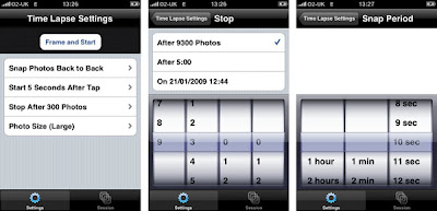
The interface is easy and intuitive to use, simple click on the Timelapse application and set the number of pictures you want to capture, image size, number of seconds to start after tapping and the delay between images.


We use 10 seconds delay and set the number of images to capture in the 1000's leaving us to stop the process whenever we wish, although you do have the option to stop at a set time and date. It is then simply a case of setting your iPhone in place, clicking 'Frame and Capture' and then leaving it running - our first sample can be seen below:


iPhone TimeLapse Test from digitalurban on Vimeo.

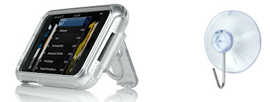
The iPhone is obviously not waterproof so to capture cloud/cityscape timelapses it is advisable to mount the iPhone as close to the window as possible, while avoiding reflections. To do this we use the Belkin acrylic case which has a handy hole on the back enabling the iPhone to hook onto a window suction cup:


If you are planning to capture more than 1000 images it is worth noting that at the moment the iPhone names images in sequence up to 1000 and the goes back to the start. With a timelapse you end up with a file sequence of 1000_1 1000_2 etc meaning that the files need to be renamed.

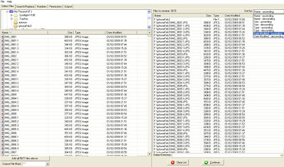
Luckily the process is relatively straight forward using ReName4U by Kelly Software. Running in Windows ReName4U allows you to list files by date captured and rename in numerical sequence, thus creating a file structure that can be ordered for a timelapse.

To rename your images simply point ReName4U to your image folder and select 'list by ascending order' - top right in the image below:


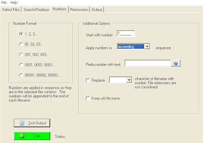
Once your files are listed, select the 'numbers' tab and chose the option to apply numbers in ascending order - then click start.


Your files are now ready to import into any number of packages to create the final movie. We use QuickTime Pro which has the option to 'Open Image Sequence', running at 25 frames per second you can produce examples similar to the next movie (it was snowing....):


iPhone Timelapse Sample 2 from digitalurban on Vimeo.


By simply turning your phone on and running the software you can get some interesting sequences - its the easiest way we have found so far for creating timelapses. Hopefully the image naming issue can be ironed out, until then its not too much a hurdle and for £1.79 it makes TimeLapse a must buy for any iPhone owning image sequence fan.

You can buy TimeLapse directly from the Apple App Store.

Live Weather Central London: Flash and iPhone


After a few months out of action due to a dodgy anemometer a trip to the roof today has bought our weather station back online.

The weather station is located on the roof of 1-19 Torrington Place, just off Tottenham Court Road in Central London, providing a live feed every two seconds.

We also have an ajax powered version formatted for the iPhone - simply double tap to zoom into each section, again data updates every two seconds:

Perfect for checking the weather in London live while sitting on the bus (or is that just us?)

View London's Weather Live, or view the mobile\iPhone version.

iPhone Google Earth

We are not going to say much about this one as its been covered elsewhere - see Franks Google Earth Blog Review and Ogle Earth's thoughts, take a look at the YouTube launch video below and if you have an iPhone we recommend go getting the app.


The concept alone was almost unthinkable a few years back, a complete 3D earth on your mobile phone and when seen in action it does deliver. Sure there are not any 3D city models yet but from a purely geographical point of view Google Earth on the iPhone is a milestone in portable visualisation.

iPhone 2.0 Excellent Location Tracking without GPS (Old iPhone)

One of the big draws of the new iPhone for us was its GPS capability and one that we are now questioning having put the new 2.0 update though its paces on an old non-GPS iPhone.

The good news is that all iPhones now do near real-time location tracking either with or without GPS. In our test our old iPhone, loaded with the 2.0 update software, updated our location approximately every 10 seconds on our trip back on the 168 to Camden Town, London, yesterday evening.

Locating via triangulation of the phone mast network and local wifi points the results were surprising accurate and certainly accurate enough for any of the new location aware apps in the iTunes store.

We were surprised to see our location updating as we moved on Google Maps to such an extent that without any actual navigation software available for the new GPS enabled iPhone we would question the need to upgrade based on a desire for locational awareness.

The accuracy of the location is determined by the density of the phone masts, so it works well in the city. We are now able to geotag our photographs, watch our location update and view services around us, all without the new iPhone.

The new 2.0 software upgrade is well worth it, for the location services alone.

iPhone in the City: Navizon - Location and Buddy Tracker

The iPhone's location finder is interesting, lacking the accuracy of the Nokia N95's dedicated GPS unit yet able to provide a fix in under 10 seconds, it is arguably more useful than a standard satellite navigation system.

Our N95 was let down by a slow fix time, leaving us looking slightly foolish when friends asked where we were, only to pull out the latest gadget which five minutes later was still trying to access satellites. The iPhone on the other hand provides an almost instant location via triangulation of phone mast signals and known wifi points.

Accuracy is limited but it works and provides a quick and easy way to orientate yourself in the city, and now thanks to Navizon you can track your friends as well. Navizon is an application that builds on the iPhones 'locate me' feature, it tracks both your and any friends location every 10 seconds issuing you with an alert when they come into a predefined range.


You can add your friends to your Buddy list with a click of a button
and then simply click on "Buddies" to see where they are on a map. Your friend will receive an notification with a link to click on and you will be able to see each other's location.

The YouTube movie embedded below provides a walkthough of Navizon:


This is the first example we have seen of near real-time location tracking of people on a consumer device. It is perhaps a landmark moment in geo-software and an indication of the route ahead as we are all becoming increasingly 'geo-located'.

There is a free trial available and more details from http://www.navizon.com